The Future of Site Surveys — From Paper to Digital
For generations, location surveys relied on paper forms, cameras, and extensive time compiling documentation. It was a sluggish, mistake-prone approach that depended on recollection and manual processes.
Today, that era is rapidly disappearing. Mobile devices, AR technology, and cloud-based teamwork have propelled field documentation into a contemporary digital age — one that's quicker, more transparent, and significantly more dependable.
Digital location surveys are revolutionising how teams in construction, retail, healthcare, facilities management and AV integration gather and share field information. The transformation extends beyond technology; it's organisational. It's about substituting estimation with exactness, and scattered notes with one unified, accessible source of truth.
Why Digital Methods Are Superseding Paper
The conventional paper-based process previously seemed logical: rapid sketches, handwritten notes, a collection of photographs to organise afterwards. However, project requirements have evolved. Timelines are more compressed, teams operate across multiple regions, and clients demand immediate updates.
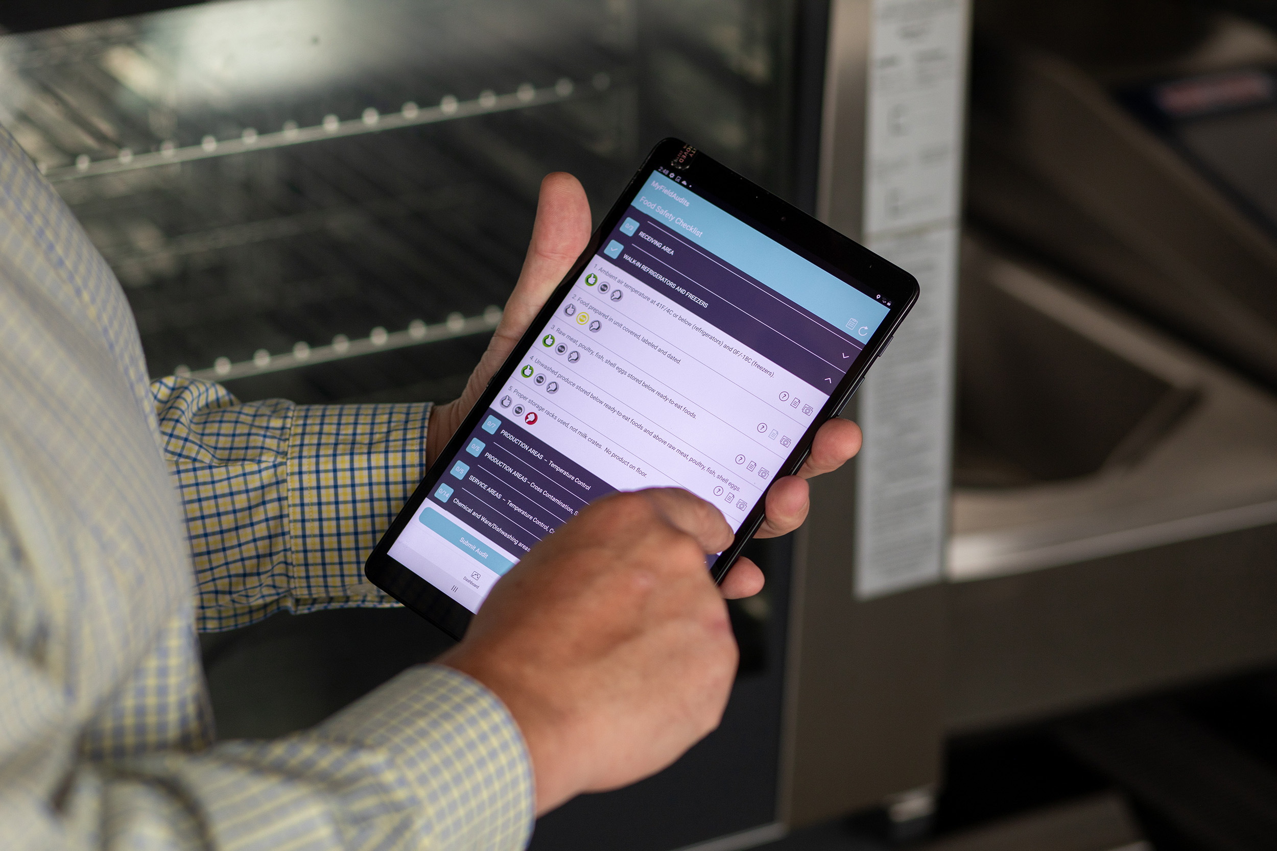
Digital solutions address these issues. Using a smartphone or tablet, any field worker can now record photographs, add annotations to images, measure spaces using AR, and transfer everything to a collaborative workspace immediately.
Eliminate retyping, reformatting, or searching for missing information. All stakeholders view identical information simultaneously.
Velocity and precision are primary drivers, but advantages extend further. Digital surveys eliminate human mistakes, maintain uniformity through templates, and deliver full traceability — every choice, annotation or note is recorded automatically.
How Digital Location Surveys Function in Reality
A standard process operates like this: arrive at location, launch your survey template in Integrio, and begin collecting. Photographs, notes, measurements, and annotations are added directly on-device.
As you progress through the space, everything synchronises to the cloud. By the time you depart location, your documentation is already finished and ready to distribute.
That identical information can be converted into professional documentation within minutes — branded, visual, and formatted automatically. Rather than investing hours assembling evidence, you're done before returning to the office.
Industries Embracing Digital Transformation
Digital location surveys have become standard practice across numerous sectors:
**Construction** – Contractors utilise them for progress monitoring, defect reporting, and client handovers. Digital images and annotations deliver clear, verifiable records at each phase.
**Retail** – Multi-location expansion teams document store layouts, fixtures, and measurements uniformly, enabling brands to preserve identical standards across every site.
**Facilities Management** – Regular inspections, audits, and maintenance checks can all be recorded with timestamped photographs and instantly produced documentation.
**Healthcare** – Hospitals and clinical settings utilise digital records to maintain regulatory compliance and guarantee installations meet rigorous safety requirements.
**AV and Smart Building Systems** – Installers design equipment positioning using AR overlays and visual annotations that eliminate uncertainty from design documents.
Each sector faces distinct challenges, but all pursue the same objective: improved communication, accelerated workflows, and fewer errors. Digital surveys provide precisely that.
Quantifiable Advantages
Teams that transition to digital documentation typically observe substantial improvements within weeks.
**Quicker completion:** Surveys that previously required half a day can be finished in under an hour.
**Fewer mistakes:** Required fields and templates guarantee nothing is overlooked.
**Immediate collaboration:** Office and field teams operate from identical, current information.
**Visual understanding:** Photographs and AR floorplans make complex information immediately comprehensible.
**Polished output:** Documentation appears uniform and client-ready every time.
These enhancements don't merely save time — they build confidence. Clients receive accurate information, and teams possess evidence of every action performed on location.
Why Integrio Is Designed for This Evolution
Integrio was developed to make digital location surveys practical for every team, regardless of sector or technical expertise.
It integrates AR floorplans, image annotation, drag-and-drop forms, and cloud collaboration into one user-friendly platform. Operate online or offline, collect information in real time, and generate documentation that demonstrates your professionalism.
The platform eliminates the requirement for multiple disconnected systems, providing one secure environment to manage everything from initial collection to client handover.
Looking Forward
The future of location surveys has arrived. Within the coming years, digital documentation will become standard procedure across every sector that works with physical spaces.
Organisations that implement now will not only save time — they'll develop stronger communication, enhanced compliance, and more efficient workflows.
If you're still managing surveys on paper or spreadsheets, this is your opportunity to modernise.